|
International Radar Consultants |
National Research Institute of Astronomy and Geophysics |


Report on
The Geophysical Survey of Tap-Osiris
Magna,
Borg El-Arab, Alexandria
Prepared
By
|
Dr. Roger
S. Vickers International Radar Consultants |
Dr. Abbas
Mohamed Abbas National Research Institute of Astronomy and Geophysics |
Presented to
The Supreme Council of Antiquities
EGYPT
April 2009
T
h e T E A M
EGYPTIAN TEAM
Dr. Abbas Mohamed Abbas Ali
Dr. Hany Salah Abdel-Azim
Dr. Usama Saad Massoud
Dr. Mamdouh Soliman
Dr. Ahmed Kotb El-Emam
Dr. Ahmed Mohsen Lethy
Mr. Abdel-Latif Mohamd Yaunis
Executive Summary
A
geophysical survey was performed on the Tap Osiris Magna site near Alexandria,
Egypt. The data was
concentrated over the Osiris and Isis temples within the site, and confirmed to
be of good quality and in the case of GPR showed penetration to 30m. But no
remarkable structures were found. We can therefore say that in
the areas surveyed,
the data shows no major tomb present. There were however, numerous
indications of small possible cavities.
Using a rule that only those features showing anomalous behavior from
two or more independent sensors would be considered, we found only two such
regions, both within the temple of
Osiris. We therefore recommend that
boreholes (3 inch) be
drilled in the two areas, with the
expectation of connecting with a small cavity or tunnel segment, but not with a major tomb. The data does not, by itself, tell if the structures
are man-made or natural, but does
give the three-dimensional location of the features that have properties that
are different from the background. It is doubtful whether the anomalies
detected, by themselves,
will result in major find. A third area, indicated
by one sensor alone, exists to the East of a known tunnel. For completeness, an additional borehole
could be drilled here,
but there are no radar echoes to suggest the presence of a tomb
or tunnel at this location.
Preamble.
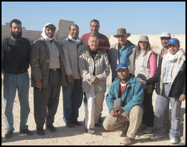
The area to be surveyed was an archeological site approximately 45Km west of Alexandria. It is approximately 88m x 90m and has been excavated (cleaned), resulting in an extremely rough surface (figure 1) which complicates the use of some of the geophysical methods. The geophysical team consisted of a group of scientific staff from the National Research Institute of Astronomy and Geophysics lead by Dr Abbas Mohamed Abbas Ali. The team, together with their areas of responsibility, was;
Dr. Abbas Mohamed Abbas Ali Team leader
Dr. Hany Salah Abdel-Azim ERT
Dr. Usama Saad Massoud VLF/GEM
Dr.
Ahmed Kotb El-Emam Mag
Dr. Mamdouh Soliman GPR
Dr. Ahmed Mohsen Lethy Mag
Mr. Abdel-Latif Mohamd Yaunis Assistant
The on site archeologist was Dr. Kathleen Martinez, who worked in coordination with Dr Zahi Hawass , Sec. Gen. of the Supreme Council of antiquities. Dr. Roger S Vickers was retained as an independent consultant primarily for the work with GPR .
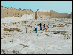
Figure 1. Tap Osiris Site looking East showing the
rough surface.
The project was conducted to provide information to support or deny the suggestion that the tomb of Cleopatra, and perhaps Mark Anthony lie beneath the Temples of Osiris and Isis inside the TapOsiris Magna complex. The tomb is believed to lie between 20 and 30m below the surface, and is accessed by either a vertical shaft or an inclined tunnel from the surface, possibly originating outside the complex. The local bedrock was limestone/ sandstone of poor quality (many small holes and inclusions) for the first 10m, grading to better quality limestone below that depth.
There were five survey methods used on the site;
Ground Penetrating Radar (GPR)
Electrical Resistivity Tomography (ERT)
Magnetometry (MAG)
Electromagnetic Sounding (EM)
Very Low Frequency Sounding (VLF)
Of these only the first two could be expected to provide information at depths beyond 10m, although all five were capable of providing data in an image format of the topmost few meters in the site. Details of the techniques are given in Appendix I. An overhead view of the site, taken before the recent cleaning work, is taken from Google Earth and is shown in figure 2.
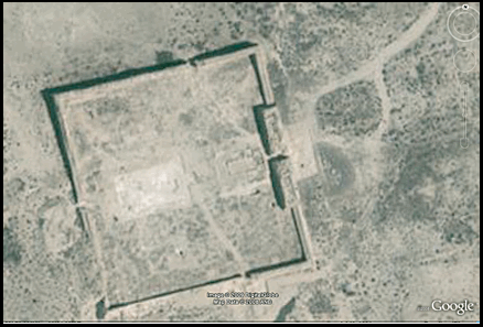
Figure 2. The Tap Osiris Site.
The Survey Work
The team arrived on the site on March 5th and left on March 13th. Survey work started at the site at 07:30 and usually finished around 16:30 each day.
The most important task for the first days was to measure the electrical properties of the host rock, so that we could calculate the maximum depth to which the various sensors, particularly the GPR, would be effective. We had been told of ground water table at 33m, and knew that there has been recent rainfall at the site. We were therefore surprised when the first resistivity soundings of the area showed the rock to be quite favorable for GPR work. The rock in fact had a resistivity of 200 ohm meters at depth, which was very good for GPR. Indicating that at low frequencies, the GPR should be able to detect anomalies down to approximately 30m depth.
With that data in hand, the team split up into different units, and proceeded to collect data with all five different sensors. The on-site archeologist stated that the highest probability of finding the tomb lay within the boundaries of the two temples dedicated to Osiris and Isis. The GPR units were therefore used for several days to perform an intense survey of this area. Early on it was found that the higher frequency GPR antennas (100, 200 and 400 MHz) did not perform well over the site, and had very limited penetration ability. The 40 MHz antenna however fulfilled our expectations based on the early measurements of resistivity, and returned echoes from as deep as 30m before becoming noise limited. This antenna was the primary GPR device used for the remainder of the survey, and was deployed over all areas of interest at the site.
Also used over the two temples was the EM and the VLF equipment along with some widely spaced ERT lines. In all, over 140 radar lines were completed, as well as a complete high-density magnetic survey of the entire site, many ERT lines, and EM/VLF data over areas of high interest.
An illustration of the 40 MHz GPR in use is shown in Figure 3,
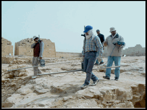
Figure 3. 40 MHz GPR Antennas in use
The Geophysical Methods used
at Tap Osiris Magna
1.
GPR
Ground penetration radar is a well known technique for investigating the subsurface in a non-destructive manner. It acts very much like an acoustic echo sounder except that it uses electromagnetic waves instead of acoustic waves. It can be fitted with antennas that radiate different frequencies. Low frequencies, (typically less than 100 MHz) give greater depth of penetration but at low resolution, while higher frequencies (typically 100 - 1000 MHz) give increasingly better resolution at the expense of poorer depth of penetration. Figure 4 shows the 40Mhz antennas being assembled, with the 100 MHz antenna off to the side. The depth ability of GPR is controlled by the resistance of the soils/rocks through which the radar wave has to pass. The higher the resistivity, the better the penetration. Other limitations also affect the GPR's ability, but the resistivity is by far the most important. In many surveys, it is a good idea to take a measurement of this quantity before mobilizing a GPR team.
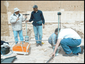
Figure 4. GPR Antennas being assembled.
2.
ERT
Measurements of electrical resistivity have been made for many decades, but more recently, automatic switching units combined with more advanced software have allowed resistivity data to be converted into 2-D cross sections of the subsurface which are much easier to scan visually and to assess the bulk properties of the materials. One disadvantage of the software currently in vogue is that it has a limited color palette and the image shows hard boundaries between regions of increasing/decreasing resistivity, which in turn gives a visual impression of subsurface structure which does not necessarily exist. Nevertheless, it is an important technique, particularly since it is much less subject to the limitations that control GPR performance.
3. EM
The survey here used an instrument called GEM which makes similar measurements to ERT but injects the current into the ground by radiation rather than direct electrodes. The GEM unit transmits six different frequencies, and each one penetrates to a different depth. Typically the maximum depth of penetration is around 6-10m depending as usual on the soil conductivity. The data can be reduced into 2-D depth slices and viewed in a similar manner to GPR slices.
4.
Magnetometry
The team used a magnetic gradiometer on the site. This unit measures very small changes in magnetic field. These are caused by the presence of substances with magnetic properties, such as granite clay, or materials containing iron. For example, the presence of granite building blocks in a limestone structure, or clay materials bonding limestone blocks both would give rise to a magnetic signature. The data is usually reduced to a 2-D map, and shows the magnetic properties of the very near-surface. Figure 5 shows the magnetometer in use.
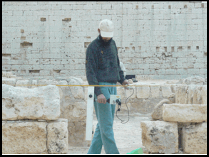
Figure 5. Magnetic Gradiometer in use.
5.
VLF.
This technique is passive, i.e. does not contain its own transmitter, and is another method for measuring resistivity . All three resistivity measurement techniques have differing sensitivity to subsurface geometry. One can use different combinations to detect vertical walls, horizontal layers, cavities etc.
Geophysical Data Acquisition
The field procedure
at the site of Tap-Osiris Magna temple was started by conducting ERT profiles
to inspect the resistivity transition with depth over the studied area. After
acquiring the needed information, we planned the best geophysical coverage to
achieve the desired goal which was to locate
subsurface conditions that indicated the presence of a large tomb, or tunnels
that could lead to such a tomb.
We were advised by Dr. Martinez that the areas enclosing the tombs of
Osiris and Isis would be the most important.
From the early resistivity data we recognized the possibility of using the conducting
GPR technique, as the soil resistivity was adequate (increasing with depth) to
accomplish the GPR survey to a depth of up to 30m.
The GPR system used was the SIR-3000 from Geophysical Survey
Systems, Inc. (GSSI). Figure
"6" illustrates the distribution of the GPR profiles that have been carried out
over the ground surface of the temple. Some other lines; not showing at this
figure; have been conducted around the well-shaft and it will be illustrated
later on its own section. The total number of the conducted GPR profiles is
149. Most of them have been measured using the multi-frequency antenna 40MHz.
The 100 MHz and 200 MHz antennas were used only at a specific
locations (over the tunnel, around the well-shaft and against the
southern wall of the well-shaft). All the GPR measurements have been carried
out in time-domain. The horizontal distances were measured and then incorporated
to the GPR profiles by interpolating the traces along the profile.

Figure 6. Distribution of the GPR profiles over
the temple site.
The
ERT data were conducted using SYSCAL R2 system from the IRIS company. The
system was combined with multi-electrode switching units so automatic switching
between the operated arrangement of electrodes could be used to collect data
for use in the preparation of 2-D pseudo-sections. . The acquisition was handled
utilizing Wenner electrode configuration with equi-offset-distance between
electrodes 2.5 or 3 m depending on the maximum available horizontal distance.
Sum of 20 ERT profiles were carried out allover the temple site as shown in figure
7.
The
electromagnetic survey was performed with two independent procedures, which were:
The ground conductivity measurements using GEM 300 device from the GSSI company
and the conductivity measurements using the very low frequency "VLF" WADI
device from the ABEM company. Those techniques were applied as in figure "8" at
3 grids (A,B and C).
The survey
using the magnetic technique was accomplished all over the whole temple site
using a gradiometer FM-36.

Figure 7. Distribution of the ERT profiles over
the temple site.

Figure 8. Distribution of the GEM/VLF zones over
the temple site.
Results
The
GPR data was processed to remove the unwanted outside interference signals.
Then, time/depth conversion has operated to the whole data set. A sample of the
GPR profiles over Osiris Temple are shown through figures (9 and 10), from
which it can be seen that interpretation using just individual profiles would
be difficult, and so we processed the data to form time (dept) slices over a larger area.
Time-slice
processing , converted to depth for the conducted
parallel GPR profiles over Osiris temple has been performed and sample of the
result is shown on figures 11 (a and b) and 12 (a and b).
In these slices, we looked for echo structure that persisted for more
than a single slice,
and also that coincided with high ERT values for the same area.
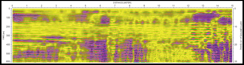
Figure 9. GPR profile "108"
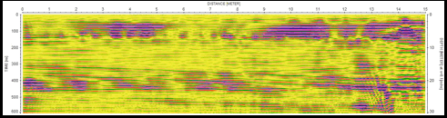
Figure 10. GPR profile "111"
|
"a" |
"b" |
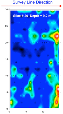
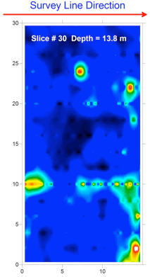
Figure 11. GPR time-slices a) at depth 9.2 m b)at depth
13.8 m.
|
"a" |
"b" |
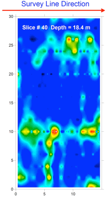
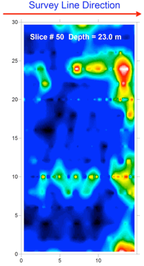
Figure 12. GPR time-slices a) at depth 18.4
m b)at
depth 23.0 m.
The
ERT data was processed using program RS2DINV to generate the true resistivity
tomography section through a least square inversion technique using finite
difference method. Examples of the ERT profile results are illustrated through
figures (13, 14, 15, 16, 17 and 18). These figures indicate some important
features which may have an archaeological meaning. ERT profile "P7" is passing
over the tunnel of 8 m depth and it is quite reflected on the profile.

Figure 13. ERT profile P7 passing by part
of the tunnel to the south of Osiris temple.
Profile
ERT "P8" (figure 14) shows an increase of resistivity with depth and it may
indicate some extension for the tunnel to the south of Osiris temple.

Figure 14. ERT profile P9 passing parallel
to the eastern edge of Osiris temple.
The
anomaly that appears at the eastern part of profile ERT "P15" (figure 15) could
be attributed to some extension of the tunnel.

Figure 15. ERT profile P15 passing over the
tunnel to the southern edge of Osiris temple.
Three
ERT profiles "P18". "P19" and "P20" are passing in part of them through Osiris Temple.
Some anomalies were recognized on the profiles and fortunately they are located
under Osiris Temple as demonstrated through figures 16, 17 and 18.

Figure 16. ERT profile P18 passing
approximately at the middle of Osiris temple.

Figure 17. ERT profile P19 passing at the
west of Osiris temple.

Figure 18. ERT profile P20 passing at the
western edge of Osiris temple.
The
GEM data was collected over 3 areas (A, B and C). The readings of each
frequency were contoured using program SURFER 8.0 and exemplified through
figures 19, 20 and 21. In general, they can imply the vertical distribution of
the conductivity through out the surveyed grids. Some features could be
recognized due the boreholes drilled at the site and other limited features,
which not implying any archaeological implication.

Figure 19. GEM results of area "A".

Figure 20. GEM results of area "B".

Figure 21. GEM results of area "C".
The
VLF survey was completed over the same grids of GEM. The in-phase and
quadrature components then contoured to provide the maps which are shown on
figures 22, 23 and 24. We can not comment meaningfully on these maps as they do not show
any information more than the transition in conductivity. The VLF data set will need considerable
extra effort in processing to remove measurement artifacts and extract any
interpretive results. At the
moment, we do not anticipate any new information from this data set.

Figure 22. VLF results of area "A".

Figure 23. VLF results of area "B".

Figure 24. VLF results of area "C".
Finally,
we have to show the resulted map of the magnetic survey (figure 25). It
reflects some surface anomalies which could be attributed to fills of shattered
potteries and the presence of pieces of some metallic based rocks such as granite.
These indications could imply the presence of some caves filled with a
collection of shattered potteries or pieces of
granite.

Figure 25. Resulted magnetic map over Tap
Osiris Temple site.
Conclusions and
recommendations
Inspection of the various sensor data sets showed that the data collection was high quality (low noise or interference), and that further repeat collection was not necessary. Examination of the data over a known tunnel (figures 26 and 27) showed that it gave a signature on both radar and resistivity equipment which could then be used if necessary to compare with radar returns in other regions. The radar signature was not as clean as that from resistivity, probably due to edge effects from the two shafts at each end of the test tunnel.
The data so far has shown three areas that are of interest, although none of them have signatures corresponding to a tomb. The areas are ;
1. Resistivity data shows a volume of high resistivity, same values as the known tunnel, to the East of the tunnel and possibly connected with it. There is no corresponding radar signature over the area, and it is therefore the lowest priority of the three we are describing. Nevertheless, a location for a suitable borehole is shown in figure 30.
2. GPR and
Resistivity data both show two areas in the Osiris temple which deserve
investigation (figures 28 and 29).
One of these is in the mid-line of the western edge of the Osiris temple, and the other is at about 20m depth on
the SE corner of the temple.
We suggest
that the fastest and cheapest investigation technique would be to
drill three 3 inch boreholes (figure
30) in the site so that either the drill will penetrate the suspected cavity,
or if not, will provide the
opportunity to put special borehole sensors down the holes and allow the detection
of any nearby structures.
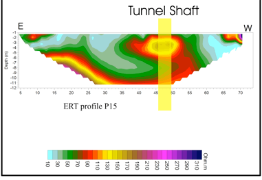
Figure 26. The yellow bar indicates the
tunnel shaft on ERT profile P15.
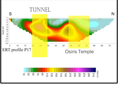
Figure 27. ERT profile P17 passes through
the tunnel and by Osiris Temple as indicated by the yellow bars.

Figure 28. GPR and ERT anomalies over the SE corner of Osiris Temple.

Figure 29. GPR and ERT profiles at the west of Osiris Temple.

Figure 30. The locations of the suggested boreholes.
January 2, 2021
Roger S.Vickers