by Lambert Dolphin
![]()
In a separate essay, Geophysics and the Temple Mount, I described our failed attempt to conduct geophysical remote sensing experiments in the Rabbinical Tunnel in search of subsurface features under the Temple Mount. Although the casual observer may conclude that all our 1983 efforts were in vain, such is not the case.
For the benefit of our more technically minded readers this section briefly summarizes the work of our field team at other sites in Israel during our April-May 1983 field season in Israel.
Project Letter Report to Dr. Ehud Netzer
Seven miles southeast of Bethlehem, visible from the main highway, is a conspicuous lone mountain which resembles a volcano. However, the flattened top and 120 feet high talus slopes are man-made. This modified mountain, known as the Herodium, is another one many monuments to himself built by the notorious Idumean King Herod the Great, (73 B.C.- 4 B.C.). Herod usurped the legal dynasty of the Hasmonean dynasty and ruled ruthlessly, destroying all who opposed him, including members of his own family. He is best known in Christian history for the massacre of innocent children in Bethlehem in his futile attempts to destroy the newborn Messiah (Matthew 2). Herod also enlarged the Second Temple.
Josephus (Antiq. xvii.6.1-8, Wars i.33.1-9) describes Herod's funeral procession from Jericho where he died, to the Herodium where he was buried:
After this they betook themselves to prepare for the king's funeral; and Archelaus omitted nothing of magnificence therein, but brought out all the royal ornaments to augment the pomp of the deceased. There was a bier all of gold, embroidered with precious stones, and a purple bed of various contexture with the dead body upon it, covered with purple; and a diadem was put upon his head, and a crown of gold above it, and a scepter in his right hand; and near to the bier were Herod's sons, and a multitude of his kindred; next to whom came his guards, and the regiment of the Thracians, the Germans also and Gauls, all accoutered as if they were going to war; but the rest of the army went foremost, armed and following their captains and officers in a regular manner; after whom, five hundred of his domestic servants and freedmen followed, with sweet spices in their hands; and the body was carried two hundred furlongs to Herodium, where he had given order to be buried. And this shall suffice for the conclusion of the life of Herod. (Josephus, Wars excerpt)
Professor Ehud Netzer of the Hebrew University at Jerusalem has excavated at the Herodium for many years, clearing debris, opening tunnels and cisterns and restoring the site so that it is now partially restored, attractive and accessible to tourists.
The roof and upper stories of the Herodium mountain fortress have long since disappeared, but four towers remain. The eastern-most tower, originally 120 feet (now only 50 feet tall), is 60 feet in diameter above the tamped-earth floor. From the top and all other outward aspects this tower appeared solid throughout.
On our very first day of work at the Herodium our geophysical radar and seismic teams decided who could be the first to explore this "solid" tower using two different sensing technologies. It was only a short time later that both teams, within minutes of each other, announced to our incredulous archaeologist host that this the solid Eastern tower contains a large room near the base!
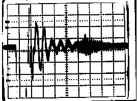
Figure 1: Radar reflections from a hidden room in the Eastern Tower of the Herodium. The radar transmitter pulse is to the left and the extended echo from the chamber begins just past mid-screen. The distance to the echo from the outside of the wall is 17 feet and the room appears to be more than 10 feet in diameter. To date this chamber has not been opened.
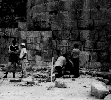
Figure 2: Radar antennas placed against the base of the Eastern Tower of the Herodium. Our measurements by both radar and seismics confirm the existence of a large room inside the tower.
Prof. Netzer felt it was unlikely that a king would be buried in a building that was still in use as a residence. His personal feelings were that the tomb location was more likely to be near the base of the Herodium.
In addition to the mountain-top fortress, the Herodium complex, which covers more than 50 acres, originally included a large monumental palace and a 150 by 200 foot swimming pool surrounded by a luxuriant royal garden, both fed from distant aqueducts. Distinct remains of a thousand-foot long hippodrome, or horse race track may be seen even today.
Perhaps, Netzer told us, the tomb of Herod the Great was beneath a later Byzantine Church built over what was originally an important Herodian ceremonial or "monumental" building.
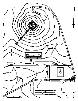
Figure 3: Diagram of the Herodium complex, looking South. The Byzantine Church and Herodian Monumental Building are indicated as site 7 at the West end of the hippodrome.
After taking resistivity data - to measure the dirt floor thickness over bedrock - of the summit palace, and following some further inconclusive radar and seismic explorations around the summit buildings and tunnels we relocated our radar and seismics equipment on the tiled floor of the old church building Netzer suspected was the best candidate site for Herod's tomb.
Soon our radar work had revealed that shallow cavities lie a few feet under the floor of the ancient Byzantine Church. These, we understand, are likely to be the tombs of early bishops of the church. They would date at least three centuries later than Herod's time. Yet both radar, and also our parallel seismics searches, revealed several additional chambers were located deeper beneath the floor. The most significant of these rooms was measured to be 21 feet beneath the floor. Although we were excited by these results and reported everything to Netzer with enthusiasm, no "ground-truth" excavations to verify our finds have yet been made at either the Eastern Tower or the Monumental Palace, quite possibly because of lack of funds.
Our modest 1983 geophysical pilot project - a few days of effort only - at the Herodium also received stormy publicity in the United States as did our aborted attempt to explore the Temple Mount described elsewhere. The Sacramento Bee ran the following story:
IMAGINE INDIANA JONES WITH HAN SOLO GADGETRY
The tomb lay buried-secreted under a fall of rock from another burial site.
For centuries, grave robbers passed it by. Archaeologists, armed with educated guesses, fumbled blindly around it.
It took British archaeologist Howard Carter six years of searching through hot dust and rocks before in 1922, he uncovered the tomb of Tutankhamun, boy king of Egypt. It had stayed untouched, crammed with the trappings of a king, for more than 3,000 years.
Recently a group of California engineers retraced Carter's tracks. Standing as he did in a dark tomb above Tutankhamun's, they set up acoustic sound equipment. It took them thirty minutes to get a reading on the burial site beneath their feet. "That's what we can do best-save time," says Lambert Dolphin, a physicist with SRI International, a private research firm in Menlo Park. Dolphin was one member of the team that "rediscovered" Tut's tomb. . .
As well as working in Egypt, the SRI team has helped sort through buried cities in Israel. Last year, it discovered a chamber inside what was thought to be a solid tower in the mountain fortress of Herodium, the summer residence of Herod the Great. Israeli archaeologists excavating the site think the chamber-15 feet in diameter-could be the tomb of Herod, who ruled from 73 B.C. to 4 B.C. Archaeologists have been searching for the tomb, thought to be full of gold and artwork for years.
"We've given some hot leads in a needle-in-a-haystack search" Dolphin said. But now they still have to do the excavation and that takes time. I want to make the point that archeology is a time-honored profession and while this equipment can help, it will never replace the plain old hard work.
Because our team had possibly discovered Herod's tomb the wire services picked up the story and it was printed nation wide. Some of the headlines read as follows:
Physicist Says He Has Found Herod's Tomb
The New Haven Connecticut Register, October 30, 1983
Secret Chamber Possibly Lost Crypt of King Herod
Herald and News, Klamath Falls Oregon, October 31, 1983.
Geophysicist Looks For Herod's Tomb With Aid Of Radar, Sonar
Times Union, Albany, New York, November 24, 1983
The New York Tribune ran the following story.
Tomb of Herod located: physicist Menlo Park, CA
A California physicist believes he has located the tomb of Herod the Great deep within the base of an ancient tower in the Judean hills south of Jerusalem.
If the discovery proves true it would be a major archaeological find and the first attributed to sophisticated new equipment which can "see" through earth and stone.
Lambert Dolphin, a geophysicist with SRI International said that during this summer his seven-member team working at Herodium found a secret chamber in the base of a large, otherwise solid tower. He said he believes this is the long-sought tomb of Herod.
"The very large tower on top of the mountain previously thought to be solid, has a chamber in it, and there should be no chamber in it at all. There is no other reason for the chamber," the scientist said.
Dolphin said he believes Herod "was probably trying to conceal his tomb, and the tower was a good place to conceal a chamber. There is no entrance."
He said the chamber, estimated to be 8 or 10 feet in diameter, is concealed 15 feet within the tower, which is 60 feet in diameter.
The mysterious room in the Herodian tower was located by the use of high technology devices built at SRI, an organization that carries out extensive research for the Department of Defense and other clients.
The instruments used by the SRI team included rock penetrating radar, sonar devices and electrical equipment similar to that used by oil and mineral prospectors.
"I am a physicist and my specialty is the application of geophysics to the service of archaeology," Dolphin said. "Archaeology is ordinarily very slow. You dig a little. You use a whisk broom. You use toothpicks. You sort out everything and when you're done you've destroyed the area.
"We can give the archaeologist a map and tell him where to concentrate his digging."
. . . Dolphin believes the newly discovered chamber in the tower a more probable location because there is no other ready explanation for it.
"The burial customs of the ancient Israelite kings was certainly not as lavish and splendid as an Egyptian Pharaoh," said Dolphin. Nevertheless Herod's tomb would probably contain "shields, swords, a crown perhaps, and mementos of his personal life.
Dolphin said it is possible that Herod's tomb was discovered and looted in the year 1120 when Crusaders visited Herodium and later described several caves there. However, he said, even if that is the case, "Something that has not been explored since the time of the Crusades is well worth exploring.
Our SRI team had never claimed to have found Herod's tomb only several cavities and voids in suspicious areas that could be the possible location of Herod's tomb. However some of the newspapers did sensationalize the story making our expedition seemingly the discoverers of Herod's burial place.
Our team and sponsors were embarrassed that our modest efforts in Israel had provoked so much sensationalism and speculation in the news. Yet my colleagues and I have confidence that we have proven that a room exists in the Eastern Tower of the Herodium and that as yet unexcavated chambers lie under the Monumental Palace at the base of the mountain. Only time will tell whether Herod's burial place has been disclosed by our geophysical methods. I feel confident that a modest investment to enable Netzer or others to excavate these two significant geophysical anomalies will yield valuable finds, even if the actual tomb still eludes detection. In that case further geophysical exploration at the Herodium in search of Herod's tomb seems to us to be a worthy project. Many acres around the base of the Herodium await archaeological exploration.
Addendum, May 15, 2007:  Tomb of Herod the Great Discovered by Ehud Netzer
Visitors to Jerusalem today will find, just inside the Jaffa Gate, the magnificent Museum of The History Of Jerusalem, and outdoor theater, within the ancient Citadel. Herod the Great built three towers there over earlier foundations to defend his adjacent palace. Many believe the Citadel is the site of the Praetorium at which Jesus was condemned to death. It was the scene of a later massacre of Roman soldiers during the First Jewish Revolt. Mamluk and Ottoman rulers later built extensively on the site.
In 1983 this fortress was under intensive excavation and restoration by archaeologist Giora Solar. Learning of our work on at the Herodium, Solar inquired if our radar could tell him if the great tower of Herod (possibly the ancient Phasel tower) at the Citadel contained any hidden chambers. The lower courses of masonry of the tower are Herodian. Solar presumed the tower to be solid throughout, but why not have a look?
Our radar measurements quickly showed that here indeed was a solid tower. No hidden chambers crammed with gold, bones, or Roman armor lay within.
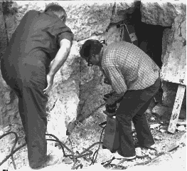
Figure 4: Radar Probing of the Tower of Herod in the Citadel. The high-frequency radar antennas in the background were simply leaned up against the wall at various locations around the tower for the measurements. No hidden rooms or voids were discovered within the tower.
As long as we had the run of the place, our field crew used both the radar and the seismic sounder to probe not only the tower but some of the thick walls in the citadel. No secret rooms emerged, however our seismic studies uncovered one hidden room full of rubble near the top of Herod's tower in a later addition to the tower.
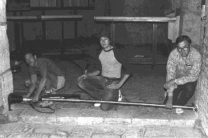
Figure 5: Seismic sounding within the walls of the Citadel in Jerusalem. The black, tapered transmitting seismic transducer is being pushed against the wall on the left by means of a long rod and spring mechanism. The receiver is not shown but was located on the opposite side of the thick stone wall which was being investigated. A coupling gel is used to assure that the sound waves enter and leave the rock properly.
Two-days' effort at the Citadel was not a great expense for our three man team. We were reminded that even negative findings can be helpful in dispelling myths and reassuring the archaeologist that, in all probability, nothing of interest lies within a tower or behind a wall. Not only was little time required for our measurements we left no holes or rubble to scar the monuments or to leave any traces of our efforts. Giora Solar seemed well-pleased to have our findings handed over to him at the end of the working days on site.
Ze'ev Yevin of the Israel Department of Antiquities and Stanley Goldfoot were our helpful field guides during our brief 1983 radar and seismic exploration of the tomb of Abraham, Isaac, Jacob, Sarah Rebecca and Leah at Hebron. The building over the traditional site of the cave purchased by the Patriarch (Genesis 23, 25:7-10, 49:28-35) is known to the Jews as the Macpelah, and to the Arabs as the Haram el Khalil. The building is Herodian embellished by minarets and roof decorations dating from the time the Moslems overcame the Crusader control of the Holy Land, or later. The subterranean rooms under the building were last opened to the outside area at the time of the Crusaders when the caves or rooms were used for intrusive burials. In 1967 Moshe Dayan lowered a small girl with camera through a small hole in the floor thus gaining some information on the basement rooms, as well as ending a 700 year old ban on non-Moslems entering the Haram. Since 1967 the site has been both a mosque and a synagogue, and it is of course a hallowed spot for Christians since Abraham is not only called "the friend of God" but also "the father of all who believe" in the Bible.
Very little is actually known about the caves or even the rooms under the floor of the Macpelah, so my colleagues and I were exited to probe through all four outside walls of the building on a one-day visit. (We asked for, but could not obtain, permission to make cart radar and seismic soundings vertically downwards through the floor inside the building - that viewing geometry would no doubt give very useful results).
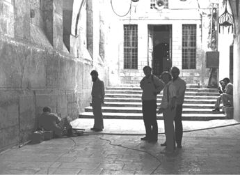
Figure 6: Geophysical crew conducting radar and seismic measurements into the caves beneath the Macpelah. All four outside walls of the building were sounded in the one working day available.
Our one day of radar and seismic data collection brought us far more echoes and reflections than we could expect to interpret in many months of labor! All we had time for was to map and tabulate hundreds of echoes and write our friends in Israel a short letter report. Our conclusions: the subterranean rooms and caves under the floor of the Macpelah are many and complex. We can only hope the entire underground complex will be excavated and explored by the archaeologist in the near future. We would love to be on hand to do more geophysical work, especially if it became possible for us to view downwards through the floor of the building.
The Bible recounts that good kings were given a memorial funeral bonfire. The whole country would come to the event according to archaeologist Gabriel Barkay. Our team used resistivity and radar to map one of the most prominent of the extant bonfire mounds believed to be that of King Hezekiah who ruled Jerusalem for thirty years in the tenth century B.C. Although Barkay has recovered gifts and memorials offered to God on behalf of the king, this mound did not prove to have any significant internal features that we could discern with our instruments. Children in the adjoining suburb of Jerusalem ride their sleds down this hill probably aware that the hill is not natural, but an ancient monument to one of their most prominent forefathers. In spite of our negative geophysical findings we felt a strange and close connection with a great, historic king we could read about in the Bible (2 Kings 18-20, 2 Chronicles 29-31, Isaiah 36-39).
Bar-Ilan University archaeologist Israel Finkelstein began to excavate the tell of Shiloh in 1981, concentrating on the areas of the tell believed to be the center of religious and political life during the time of the Judges. Tell Shiloh, about 31 kilometers North of Jerusalem, is not a natural hill, but an artificial mound of cities built upon cities. The tell extends over about 12 acres. The Ark of the Covenant and Tabernacle of Moses were located at Shiloh during the period of the Judges. A modern Jewish settlement is adjacent to the tell, in the upper right hand corner of the photo.
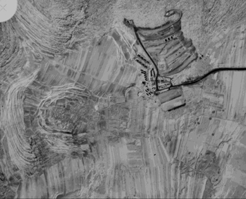
Figure 7: Aerial view of Shiloh. The ancient tell is in the lower left, the modern Jewish settlement is at upper right.
Once again our team felt it was a great privilege to work for a few days alongside one of Israel's fine young archaeologists, and at such an historically important site as Shiloh. Driving to and from the site we read from the books of Joshua, Judges and First Samuel to remind ourselves of the centuries of history that had taken place here.
As much as we had all hoped that radar and resistivity would help identify key areas or rooms associated with the area at the tell where the Tabernacle had stood, the radar records were a hopeless jumble of reflections we could not sort out. Most of the tell was too rough and uneven to use the cart radar. However, as excavation proceeds it is entirely possible that limited radar studies might be of value from time to time. Tells can be enormously complicated structures. We were all impressed with the painstaking efforts required of the archaeologist who seeks to unravel their mysteries.
Few visitors to Jerusalem realize that one of the Roman Siege camps from A.D. 70 lies near the front gate of St. Andrew's Scottish Presbyterian Church and Hospice just South of the Valley of Hinnom across from Mt. Zion. Alongside the church runs the ancient Roman Road to Hebron and Bethlehem. Rock-cut tombs explored by Gabriel Barkay of Tel Aviv University have revealed not only many bones and artifacts, but an important small artifact of silver inscribed with the name of God dating from First Temple Times.
In several working days our radar and resistivity teams explored the Roman road and the roadsides near the church for a distance of several hundred feet. Very quickly we were able to pinpoint at least 5 additional tombs (since excavated). What may have been even more helpful to the archaeologist was our ability to map out large strips of "barren ground" eliminating any unnecessary digging efforts. Who knows have many thousands of soldiers, Israelites and even Jesus and and family had walked over the road we were now probing with modern sensing methods in search of ancient tombs. The long dead tomb owners surely never dreamed their resting places would be discovered in such a manner.
![]()
1. Abraham Rabinovich, Jerusalem Post, August 1, 1983
2. Deborah Blum, Science Writer, Sacramento Bee, Sunday, October 14, 1984
3. Richard M. Harnett, United Press International, New York Tribune, November 8, 1983
4. Nancy Miller, Patriarchal Burial Site Explored for First Time in 700 Years, BAR, May/June 1985, pp 26-43.
![]()
Lambert Dolphin
lambert@ldolphin.org
Lambert Dolphin's Library
The Temple Mount Web Site
revised June 29, 1995. January 20, 2005.
![]()